Location: Gorongosa National Park
Photo: Bart Wursten
Gorongosa National Park Logo
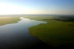
Photo: Bart Wursten
Lake Urema.
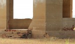
Photo: Bart Wursten
Liona are back at Lion House
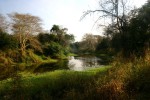
Photo: Bart Wursten
Musikadze River
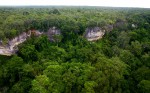
Photo: Bart Wursten
Densely forested limestone gorges along the eastern Cheringoma escarpment.
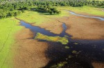
Photo: Bart Wursten
Typical floodplain vegetation flanked by forests of Faidherbia albida, Vachellia xanthophloea and Hyphaene palms. and
General Information
Quarter degree square: 1834C1-4, 1834D1-4; 1934A1-2, 1934B1 Country: Mozambique Habitat: Large floodplain areas of seasonally inundated grassland; Acacia xanthophoea and palm woodlands; dry deciduous woodlands; mixed miombo; sand forest; inselbergs; limestone gorges; lakes, rivers and swamps Altitude range: from c. 400 m on the western escarpment down to 20 m on the flood plain and up to c. 300 m on the eastern plateau. Annual rainfall: Location (short): One of the major National Parks in Mozambique situated at the very southern tip of the Great Rift Valley Location (detailed): For more information see Gorongosa.org. |
Description
Useful links
View a list of records for Gorongosa National Park
View a list of unique taxa (excluding cultivated plants) for Gorongosa National Park
View a list of unique taxa (all taxa whether cultivated or not) for Gorongosa National Park