Location: Malilangwe Wildlife Reserve
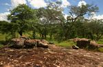
Photo: Bart Wursten
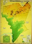
Photo: Bart Wursten
Map of Malilangwe
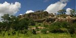
Photo: Bart Wursten
Sandstone ridges in the northern part of the Reserve.
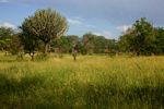
Photo: Bart Wursten
Abundant annual legumes (Crotalaria virgulata) in rainy season grassland.
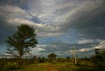
Photo: Bart Wursten
Deciduous woodland during the rainy season.
General Information
Quarter degree square: Primarily in 2131B2 Country: Zimbabwe Habitat: Hot, dry deciduous open woodland and grassland, seasonal pans, riverine vegetation, dams and sandstone rock formations. Altitude range: c.300 - 450 m Annual rainfall: Location (short): Location (detailed): |
Description
Useful links
View a list of records for Malilangwe Wildlife Reserve
View a list of unique taxa (excluding cultivated plants) for Malilangwe Wildlife Reserve
View a list of unique taxa (all taxa whether cultivated or not) for Malilangwe Wildlife Reserve