| Home | > | List of locations | > | Chimanimani Mountains National Park |
Location: Chimanimani Mountains National Park
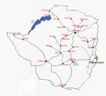
Photo: Bart Wursten
Map showing location of Chimanimani Mts National Park.
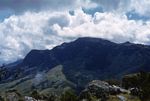
Photo: Rawdon Goodier
Eastern scarp forests
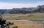
Photo: Rawdon Goodier
View over the Bundi River plain
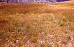
Photo: Rawdon Goodier
N end of airfield; grasslands on schists and quartzites
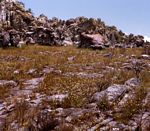
Photo: Rawdon Goodier
Quarzite pavement with Xyris
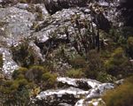
Photo: Rawdon Goodier
Ericaceous scrub with Aloes & Calomeria on Dombe
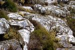
Photo: Rawdon Goodier
Summit vegetation on Dombe with Ericaceae & Helichrysum
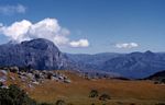
Photo: Rawdon Goodier
The Corner from Martin's Falls path
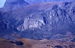
Photo: Rawdon Goodier
View east from Melsetter (Chimanimani)
General Information
Quarter degree square: Mostly 1933C3 Country: Zimbabwe Habitat: Afromontane forest, woodland, scrub and grassland habitats Altitude range: 1100 - 2436 m Annual rainfall: Probably over 1500 mm per year Location (short): Forming the border between Zimbabwe and Mozambique Location (detailed): This rugged mountainous park lies in Chimanimani district, Manicaland, where it forms the eastern border with Mozambique. It is managed by the Zimbabwean Department of National Parks and Wildlife Management. |
Description
The Chimanimani Mountains are an important 'island' of the 'Afromontane archipelago', the chain of mountain groups stretching from the Cape to the high mountains of East Africa. Their peaks rise to about 2,440 m on the border between Zimbabwe and Mozambique. The area, which in Zimbabwe includes the Chimanimani National Park, is of outstanding botanical and ecological interest. The mountains are formed by alternating strata of schists and quartzites. The schist soils bear a flora allied to that of the upland eastern districts generally but the quartzites, and the soils derived from quartzite, bear a very distinct flora including, at the latest estimate, over 80 species which are endemic to the Chimanimani Mountains. These include Protea enervis, Platycaulos quartziticola, Helichrysum africanum, Aeschynomene chimanimaniensis, Disa chimanimaniensis etc. So far it would appear that all the endemic species are restricted to the quartzite areas. These are the only Central African mountains that have a developed ericaceous scrub zone.
[Information and images on this location by Rawdon Goodier]
Useful links
View a list of records for Chimanimani Mountains National Park
View a list of unique taxa (excluding cultivated plants) for Chimanimani Mountains National Park
View a list of recorders who have visited this location
| Home | > | List of locations | > | Chimanimani Mountains National Park |